Arctic Climate Seasonality and Variability

Arctic Regional Variability


Mean Arctic sea ice concentration for every month of the year. Averages are calculated over the 1981 to 2010 reference period. Data is from NSIDC’s DMSP SSM/I-SSMIS.
Map of latitude and longitude lines in the Arctic. The red shaded region outlines the area used in the daily temperature plots of northward of 80°N latitude (https://zacklabe.com/arctic-temperatures/).

Sea Ice Seasonal Cycle


Animation of monthly mean Arctic sea-ice concentration in the Arctic (left) and Antarctic (right). Averages are calculated over the 1981 to 2010 reference period. Data is from ERA5 reanalysis.
Mean Arctic sea ice concentration around the annual maximum (left; March) and annual minimum (right; September). Data is from NSIDC’s DMSP SSM/I-SSMIS. Averages are calculated over the 1981-2010 reference period.

Astronomical Seasons


Animation of top of atmosphere (TOA) solar radiation around the June Solstice. Data is from ERA5 reanalysis.
Animation of top of atmosphere (TOA) solar radiation around the June and December solstices. Data is from ERA5 reanalysis.
Animation of top of atmosphere (TOA) solar radiation around the March and September equinoxes. Data is from ERA5 reanalysis.
Animation of monthly top of atmosphere (TOA) net solar radiation (clear sky conditions for incoming minus outgoing solar radiation). Data is from ERA5 reanalysis.

Arctic Large-Scale Atmospheric Circulation


Animation of monthly mean near-surface air temperatures in the Northern Hemisphere. Averages are calculated over the 1981 to 2010 reference period. Data is from ERA5 reanalysis.
Animation of monthly mean sea surface temperatures (SST) in the Northern Hemisphere. Averages are calculated over the 1991-2020 reference period. Data is from OISSTv2.1. For more information on Arctic SST, check out https://arctic.noaa.gov/report-card/report-card-2023/sea-surface-temperature-2023/.

Global Climate Seasonality
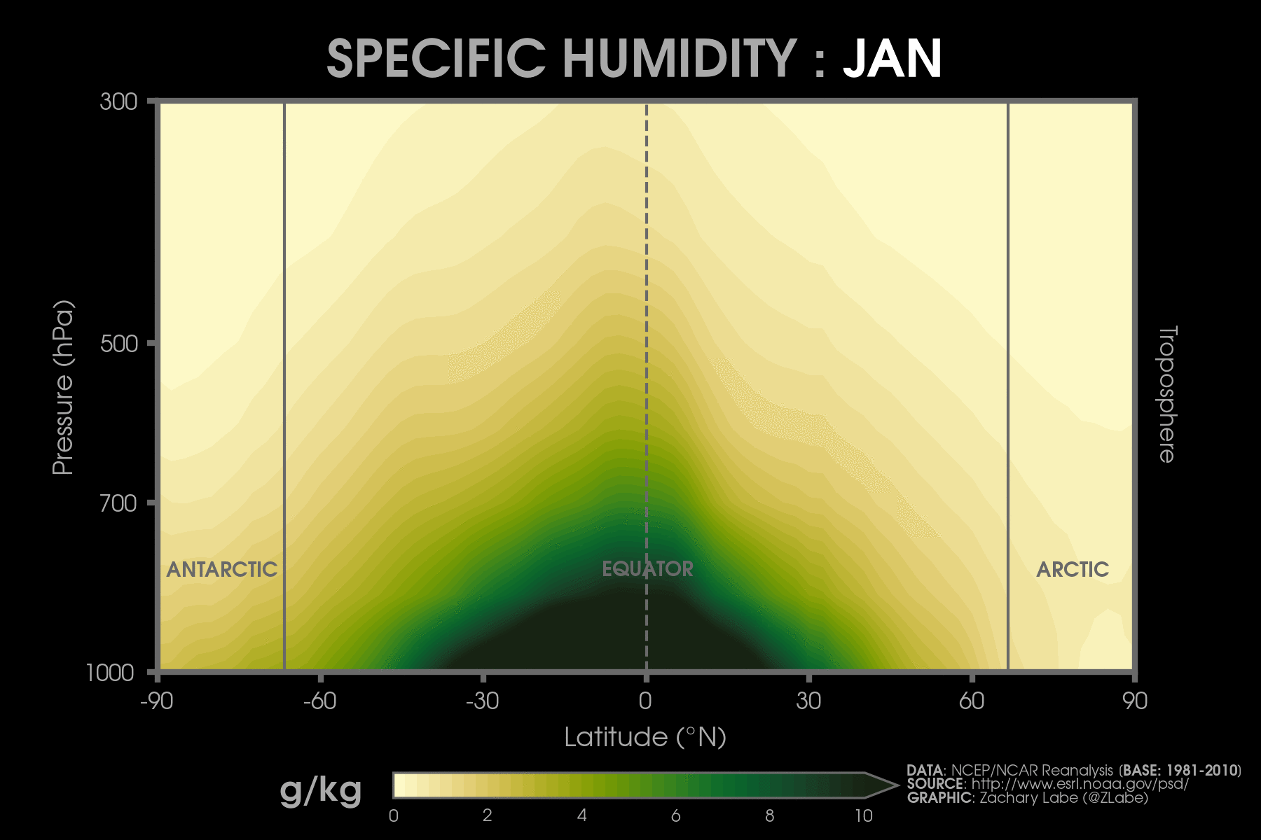

Vertical cross-section of zonal mean (averaged over longitude) temperature averaged for each month over 1981 to 2010. The solid black line is the average 0°C isotherm. Data is from NCEP-NCAR Reanalysis 1.
Vertical cross-section of zonal-mean (averaged over longitude) zonal winds averaged for each month over 1981 to 2010. Data is from NCEP-NCAR Reanalysis 1. Positive values are westerly winds, and negative values are easterly winds.
Vertical cross-section of zonal mean (averaged over longitude) specific humidity averaged for each month over 1981 to 2010. Data is from NCEP-NCAR Reanalysis 1.
Vertical cross-section of zonal mean (averaged over longitude) omega averaged for each month over 1981 to 2010. Data is from NCEP-NCAR Reanalysis 1. Omega describes the vertical motion of the atmosphere (red=descending, blue=rising).

The views presented here only reflect my own. These figures may be freely distributed (with credit). Information about the data can be found on my references page and methods page.